
Vox clamantis in deserto


Mathew Barlow/Judah Cohen: How polar vortex from the warming Arctic and warm ocean intensified our big winter storm
From The Conversation (except for image above)
Mathew Barlow is a professor of climate science at the University of Massachusetts at Lowell.
Judah Cohen is a climate science at the Massachusetts Institute of Technology
Mathew Barlow has received federal funding for research on extreme events and also conducts legal consulting related to climate change.
Judah Cohen does not work for, consult, own shares in or receive funding from any company or organization that would benefit from this article, and has disclosed no relevant affiliations beyond their academic appointment.
A severe winter storm that brought crippling freezing rain, sleet and snow to a large part of the U.S. in late January 2026 left a mess in states from New Mexico to New England. Hundreds of thousands of people lost power across the South as ice pulled down tree branches and power lines, more than a foot of snow fell in parts of the Midwest and Northeast, and many states faced bitter cold that was expected to linger for days.
The sudden blast may have come as a shock to many Americans after a mostly mild start to winter in many places in the nation, but that warmth may have partly contributed to the ferocity of the storm.
As atmospheric and climate scientists, we conduct research that aims to improve understanding of extreme weather, including what makes it more or less likely to occur and how climate change might or might not play a role.
To understand what Americans are experiencing with this winter blast, we need to look more than 20 miles above the surface of Earth, to the stratospheric polar vortex.
A forecast for Jan. 26, 2026, shows the freezing line in white reaching far into Texas. The light band with arrows indicates the jet stream, and the dark band indicates the stratospheric polar vortex. The jet stream is shown at about 3.5 miles above the surface, a typical height for tracking storm systems. The polar vortex is approximately 20 miles above the surface. Mathew Barlow, CC BY
What creates a severe winter storm like this?
Multiple weather factors have to come together to produce such a large and severe storm.
Winter storms typically develop where there are sharp temperature contrasts near the surface and a southward dip in the jet stream, the narrow band of fast-moving air that steers weather systems. If there is a substantial source of moisture, the storms can produce heavy rain or snow.
In late January, a strong Arctic air mass from the north was creating the temperature contrast with warmer air from the south. Multiple disturbances within the jet stream were acting together to create favorable conditions for precipitation, and the storm system was able to pull moisture from the very warm Gulf of Mexico.
The National Weather Service issued severe storm warnings (pink) on Jan. 24, 2026, for a large swath of the U.S. that could see sleet and heavy snow over the following days, along with ice storm warnings (dark purple) in several states and extreme cold warnings (dark blue). National Weather Service
Where does polar vortex come in?
The fastest winds of the jet stream occur just below the top of the troposphere, which is the lowest level of the atmosphere and ends about seven miles above Earth’s surface. Weather systems are capped at the top of the troposphere, because the atmosphere above it becomes very stable.
The stratosphere is the next layer up, from about seven miles to about 30 miles. While the stratosphere extends high above weather systems, it can still interact with them through atmospheric waves that move up and down in the atmosphere. These waves are similar to the waves in the jet stream that cause it to dip southward, but they move vertically instead of horizontally.
A chart shows how temperatures in the lower layers of the atmosphere change between the troposphere and stratosphere. Miles are on the right, kilometers on the left. NOAA
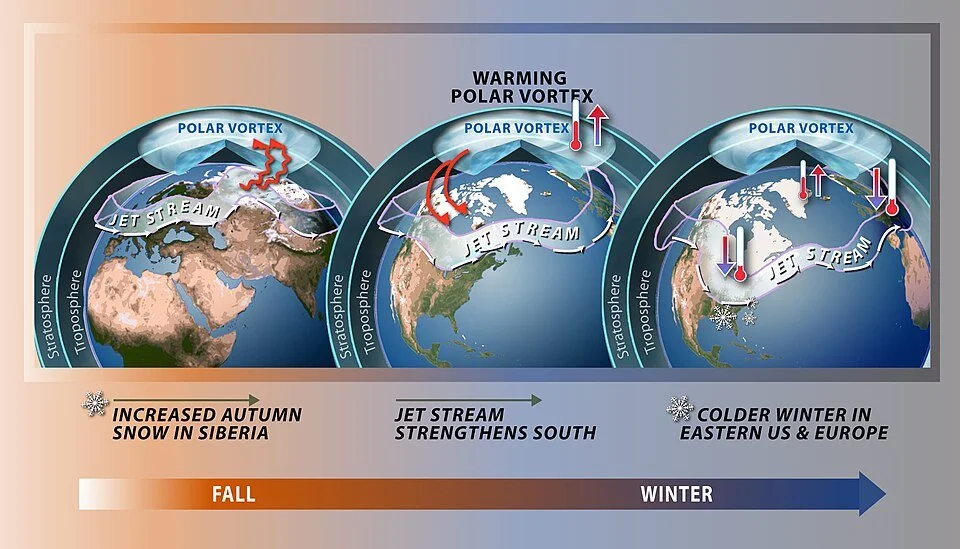
You’ve probably heard the term “polar vortex” used when an area of cold Arctic air moves far enough southward to influence the United States. That term describes air circulating around the pole, but it can refer to two different circulations, one in the troposphere and one in the stratosphere.
The Northern Hemisphere stratospheric polar vortex is a belt of fast-moving air circulating around the North Pole. It is like a second jet stream, high above the one you may be familiar with from weather graphics, and usually less wavy and closer to the pole.
Sometimes the stratospheric polar vortex can stretch southward over the United States. When that happens, it creates ideal conditions for the up-and-down movement of waves that connect the stratosphere with severe winter weather at the surface.
A stretched stratospheric polar vortex reflects upward waves back down, left, which affects the jet stream and surface weather, right. Mathew Barlow and Judah Cohen, CC BY
The forecast for the January storm showed a close overlap between the southward stretch of the stratospheric polar vortex and the jet stream over the U.S., indicating perfect conditions for cold and snow.
The biggest swings in the jet stream are associated with the most energy. Under the right conditions, that energy can bounce off the polar vortex back down into the troposphere, exaggerating the north-south swings of the jet stream across North America and making severe winter weather more likely.
This is what was happening in late January 2026 in the central and eastern U.S.
If climate is warming, why are we still getting severe winter storms?
Earth is unequivocally warming as human activities release greenhouse- gas emissions that trap heat in the atmosphere, and snow amounts are decreasing overall. But that does not mean severe winter weather will never happen again.
Some research suggests that even in a warming environment, cold events, while occurring less frequently, may still remain relatively severe in some locations.
One factor may be increasing disruptions to the stratospheric polar vortex, which appear to be linked to the rapid warming of the Arctic with climate change.
The polar vortex is a strong band of winds in the stratosphere, normally ringing the North Pole. When it weakens, it can split. The polar jet stream can mirror this upheaval, becoming weaker or wavy. At the surface, cold air is pushed southward in some locations. NOAA
Additionally, a warmer ocean leads to more evaporation, and because a warmer atmosphere can hold more moisture, that means more moisture is available for storms. The process of moisture condensing into rain or snow produces energy for storms as well. However, warming can also reduce the strength of storms by reducing temperature contrasts.
The opposing effects make it complicated to assess the potential change to average storm strength. However, intense events do not necessarily change in the same way as average events. On balance, it appears that the most intense winter storms may be becoming more intense.
A warmer environment also increases the likelihood that precipitation that would have fallen as snow in previous winters may now be more likely to fall as sleet and freezing rain.
Still many questions
Scientists are constantly improving the ability to predict and respond to these severe weather events, but there are many questions still to answer.
Much of the data and research in the field relies on a foundation of work by federal employees, including government labs like the National Center for Atmospheric Research, known as NCAR, which has been targeted by the Trump administration for funding cuts. These scientists help develop the crucial models, measuring instruments and data that scientists and forecasters everywhere depend on.
Something to look forward to

"Redbud Tree in Bottomload,'' photo by ELIOT PORTER, at the Portland Museum of Art (but photo is copyrighted by Amon Carter Museum of American Art, Forth Worth) in the Portland Museum's show "American Vision: Photographs from the Collection of Owen and Anna Wells''.
Please comment via rwhitcomb51@gmail.com
Jan. 7, 2014
Cold morning today but far from the "polar vortex'' catastrophe that it's being made out to be by the news media because their denizens think that nothing much else is going on. Of course, lots of stuff is going on but it bores those reporters and editors who haven't yet been laid off in the ferment caused by the triumph of mostly ''free'' information on the Internet. And maybe the public doesn't care all that much either.
Most importantly, "polar vortex'' sounds like a horror-movie monster. Very sexy. More vortexes to come because global warming is screwing up the jet stream? Too early to say with scientific assurance.
It's all rather typical of January, the coldest month. But February is often the snowiest because warm wet air begins to edge north again, setting up conflict with the cold air. Great for creating Nor'easters! Arctic air and the Gulf Stream can be in explosive proximity.
As I walked the dog this morning I enjoyed the crunch of my feet on the thin layer of snow that had fallen overnight as the front swung through from Canada, bringing a snow squall or two. And the frozen trees were creaking. Too cold to be slippery! The problem in the coastal Northeast is the wind. It can make urban walking miserable. When I lived in the Upper Connecticut River Valley, the temperature could be much colder than in Boston, Providence, New York and Philadelphia but the comfort level much higher because there was much less wind and it was very, very dry. Sort of exhilarating -- bright and almost antiseptically clean.
Meanwhile, along the lines of ever-more "nurturing'' of children by parents and schools (at the ones I attended we were often called by our last names and there wasn't much open concern for our feelings), is the practice of clothing our dogs for winter walks, even outside of the Upper East Side of Manhattan. I must confess that my wife and I have adopted this habit. The dog, a rescue mutt from San Antonio (via "Alamo Rescue''), fought having a coat on at the start but has since accepted it -- especially when it's windy.
My most physically painful memories of winter are in the streets of big cities with the northwest wind squeezing between the high buildings.
When it's really, really cold, ice is so sticky that you don't even worry about driving up and down steep snow-covered hills. A few times I had to drive my drunken mother to a drying-up spa at a place called Beech Hill Farm, on top of a mountain in Dublin, N.H. -- the little town where Yankee magazine was, and is, put out and where Mark Twain spent some happy times. If it was the winter, I'd pray for very cold weather. Around freezing was the most insidious, with a thin layer of melting in the sun, then quick refreezing toward evening.
The dramatic freeze-thaw cycles in New England make skiing more, well, exciting here than on the dusty, dry "powder snow'' promoted by resorts in the Rockies. Skiing in the White and Green mountains is much more of a challenge to muscles and nerves than is skiing at, say, Taos.
Anyway, I long for late February, when sun-facing cars and rooms suddenly seem to start to warm up much faster as the sun gets stronger. Even on a very cold day last week, I found the stone on a southwest-facing wall remarkably warm. We really do need to do a lot more with passive solar heating.